VANCOUVER — Nearly half of the landslides, debris flows and washouts that occurred during British Columbia's atmospheric river disaster in November 2021 originated in areas that had been logged or burned by wildfire, a study has found.
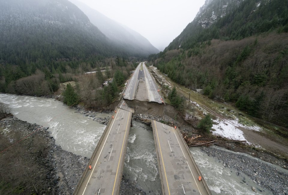
Severe rains triggered a landslide that killed five people on a stretch of Highway 99 east of Pemberton, while slides and flooding washed away bridges and large swaths of roads, cutting off coastal B.C. from the rest of the country.
About 18,000 people were forced to evacuate their homes in southwestern B.C. as the series of drenching storms parked over the area for days, flooding farms and homes in the Fraser Valley and inundating parts of the City of Merritt.
Study author Carie-Ann Hancock said she launched the research after taking a helicopter flight over the disaster as part of the effort to triage the infrastructure damage, then creating an inventory of all of the individual geohazards she found.
As she flew over the Coquihalla Highway, Hancock said she spotted five or six failures along resource roads built and used by the logging industry.
"The deposit of these landslides (was) covering a few, you know, maybe two, three lanes of a four-lane highway," she said in an interview on Friday.
Climate change is causing more frequent and severe wildfires, which in turn prime the landscape for a storm to trigger such geohazards, she said.
But forest management practices are also at play, said Hancock, a professional geoscientist with the consulting firm BGC Engineering.
"You can make the infrastructure more resilient, you can build it bigger," she said of the potential response to escalating extremes.
But the government should think about restoring the watersheds, so upgrading infrastructure isn't a Band-Aid solution, she said.
The study is published in the peer-reviewed journal Earth Surface Processes and Landforms and covered about 70,000 square kilometres in southwestern B.C., examining 1,360 debris flows, landslides and bank erosion triggered by the storm.
It found 17 per cent of those hazards originated within burned areas, while 14 per cent occurred at or below roads used by resource industries and an additional 15 per cent stemmed from logging cut blocks, for a total of 46 per cent.
Asked about the study, the Transportation Ministry said it is committed to identifying and mitigating the impacts of natural hazards on provincial highways.
Geohazard studies are conducted along highway corridors to identify unstable areas and recommend infrastructure improvements, it said in a statement.
"The ministry is also developing a risk and vulnerability assessment methodology to proactively identify and assess at-risk highway segments," it said. "This system will help prioritize investments to enhance highway resiliency and improve long-term safety."
About 4,000 square kilometres of forest in the study area had been logged since 1990, with 3,600 square kilometres logged between 1900 and 1990, said the paper, noting cutblocks that produced debris flows ranged in age from 1960 to 2021.
The study published in January looked at more than 35,000 kilometres of resource roads throughout southwestern B.C.
"Nearly half of the resource-road failures were from unmapped and presumably unmaintained resource roads," the paper said. "If these geohazards are to be effectively managed to reduce downstream impacts, significant effort would be required to map their locations and assess their current stability."
The study said B.C. has improved logging practices over the last several decades, but "the approximately 400 resource road and cutblock-related geohazards triggered by the November 2021 (storm) show that these issues persist."
In a separate statement, the Forests Ministry said hydrological and terrain stability assessments are a "critical part" of designing logging cutblocks.
"Various terrain stability and engineering assessments are undertaken before resource roads and structures are designed to withstand weather events," it said.
More than 1,600 wildfires also scorched 8,700 square kilometres of land in 2021, making it B.C.'s third-worst season on record at the time, the paper said.
The paper cites research showing atmospheric rivers are becoming more frequent and severe with climate change, which is also fuelling increasingly intense wildfires.
These trends "will likely lead to an increase in geohazards" in B.C., it said.
The statement from the Transportation Ministry said burned areas are assessed for geohazard risk and the province has implemented real-time monitoring systems in areas with a high risk of landslides, it said.
Hancock said she used LiDAR data gathered by her firm and a First Nation, in addition to satellite imagery and social media posts from the time of the disaster to create the inventory of the slides and washouts that formed the foundation of the study.
The study also looked at the sediment dumped into the Coquihalla and Coldwater rivers during the storm and how that contributed to channel instability.
It found unstable river channels influenced a further 14 per cent of the geohazards during the November 2021 disaster.
The study analyzed a 47-kilometre stretch of the Coquihalla River and found about 53,000 cubic metres of sediment were eroded per kilometre as the waterway became shallower and fanned out to accommodate the muck and debris.
"That's something like 20 Olympic-sized swimming pools, just for context. That's a lot of material being moved per kilometre of the river," Hancock said.
She said satellite imagery showed "a kind of conveyor belt that starts way up high in the watershed, maybe from a post-wildfire debris flow, putting sediment into the channel," and the waterway became larger and wider as it flowed toward the ocean.
"There's really a strong interconnection between sediments from landslides and the rivers that go downhill. So, thinking about, can we make sure that we study both at the same time when we're evaluating … where our infrastructure is."
Hancock said it will be important for provincial officials to take lessons from the 2021 disaster and apply them in areas that are expected to see more wildfires as well as atmospheric rivers in years to come, particularly in coastal B.C.
This report by The Canadian Press was first published March 21, 2025.
Brenna Owen, The Canadian Press