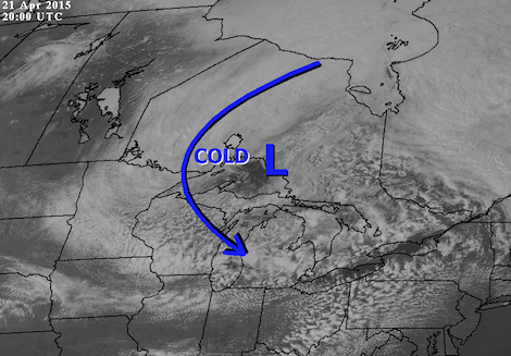
The spring-like conditions have exited the region thanks to what’s known as a cold core low.
This upper air feature is a pool of cold air that is trapped aloft.
Often these atmospheric features will stall out over a region and take several days to move out.
In the coming week we have this risk of scattered flurries and wet snow as the cold low sends pulse after pulse of unsettled weather across the region.
Often, periods of sun occur between the precipitation events, but the brief daytime heating just contributes to instability and quickly builds in more precipitation.
Such long stretches of sunshine, in cold core lows, is difficult to achieve.
By the end of the coming week, the cold core low will finally move out of the region.
It will then take several days for the spring sun to heat conditions back up to near normal values.
So spring will be put on hold, for at least a week, before warmer temperatures return to Ontario.
The attached image shows the broad extent of the cold core low, with the center located near northeastern Lake Superior.
The cloud deck extends from the Manitoba border to the Atlantic coast.
Note how the pockets of sunshine in southern Ontario created scattered cumulus clouds that will produce small hail Tuesday afternoon.